- LOCATION:
- Franklin Township
- Franklin-Trenton Rd.
- Franklin, Ohio 45005
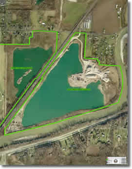
The Martin-Marietta Carl E. Oeder Park is a gravel-mining site that lies alongside the Warren County water well fields and contains a large ground water lake that is residual from the mining operation. It is a part of the Twin Creek Park and Nature Preserve Complex that is under development by the park district and offers a wonderful site for a fishing lake venue, with trails, shelters and playground facilities. The mining site is presently in the process of reclamation by Martin Marietta, which will transfer the property to the Park District when the reclamation is complete. The proposed park is located in Franklin, Ohio, population of 11,664 people, next to Carlisle, Ohio population of 4,780 and 12 miles west of Dayton, Ohio. It is 13 miles northwest of Lebanon and 3.5 miles northwest of I-75.
HISTORY
The 62-acre tract of land has been mined out by Martin-Marietta Aggregates. As soon as reclamation is complete, land will be conveyed to the Warren County Park District, completely restored and developed per agreement between Park District and Martin-Marietta Aggregates.
DESCRIPTION
Upon completion of mining, it is anticipated that the property will contain a lake with park development around the perimeter. Shelters, restrooms and a playground will be constructed, other type of development uncertain at this time. There is an area of prime level land and frontage along Franklin Trenton Rd.
| TOTAL ACREAGE: |
62 acres |
| FIELDED ACREAGE: |
Uncertain at this time |
GEOLOGICAL TOPOGRAPHICAL AND GEOGRAPHICAL CHARACTERISTICS
This land consist of Abscota Series soil, this type of soil consist of well-drained dark-colored sandy soils that are subject to flooding. These soils are nearly level and are generally between well drained Ross or Genesee soils on the flood plains. A typical profile has a dark color sandy surface layer about 12 inches thick. Brown sand extends from a depth of 12 to 42 inches. The next layer is brown, well-sorted sand and gravel. This level soil occurs along the Little Miami River, Twin Creek and the lower part of Clear Creek in Franklin Township. This area is relatively level and located in the northwest section of Warren County in Franklin Township.
PRESENT USE
Mining reclamation in progress.